

In anticipation of the five-year review of the city’s regional plan, which kicks off tonight at a public information meeting in Tantallon, a coalition of 36 environmental, business and community groups is advocating that a “greenbelt” be added to the plan.
The coalition is called Our HRM Alliance, and given the odd geography of HRM, its proposal for a greenbelt isn’t as simple as drawing a green corridor around the urban area.
Rather, the proposal consists of four overlapping maps, providing different kinds of protections and restrictions to various lands.
The first is called “Protected areas and natural corridors,” and is seen below (click here for the full-sized version):

Most of this map will be non-controversial, because a lot of the green areas are already provincially protected wildernesses: Tangier Grand Lakes, White Lake, Waverley-Salmon River Long Lake, Clattenburgh Brook, Five Bridges and Terrence Bay.
Additionally, the map includes Long Lake provincial park, the Lake Major and Pockwork watershed areas and seven wilderness parks that were proposed in the regional plan, including the Birch Cove Lakes-Blue Mountain Wilderness and the Western Common.
The alliance’s proposal also calls for the Herring Cove backlands to be designated as protected, and for wildlife corridors connecting the various natural areas to be created, with protection given to the corridors as well. The Ecology Action Centre’s Raymond Plourde says that the group is hoping the city can take the lead on establishing the location of the corridors, but they’ll mostly follow creeks and lakes, with some other innovative ideas, like a powerline corridor connecting two of the areas.
The zoning protections for these areas would be absolute: There would be no development at all in the areas, and uses would be severely restricted.
The second map is labelled “Natural resources and agriculture.” It is seen below (for the full-sized version, click here.)
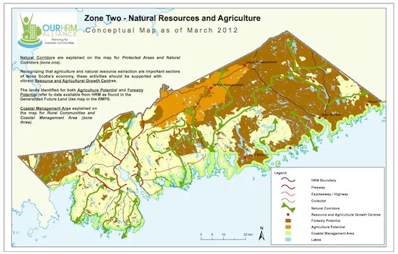
This map largely corresponds to resource zoning that is already in place, with some additions—including some potential conflicts in gold mining areas along the eastern shore, and the largest change, the designation of the so-called “Mersey” land (now Bowater-Mersey) in the hills above Tantallon as resource land.
The Mersey land has long been a logging area, with mining and, especially, hydro power uses as well, but it is not currently designated as resource land. There are tremendous development pressures on the area, as the Westwood Hills subdivision expands westerly into a valley that extends between the head of St. Margarets Bay and Uniacke. Also, the new “connector road” on highway 103 between exits 5 and 6—dubbed exit 5A—potentially opens up the southern portion of the Mersey lands to development. Already Bowater-Mersey is mapping off tracts for subdivision, and the company had a presence during the adoption of the regional plan in 2006.
The third map, designated “Rural Communities and Coastal Management” is below. (See the full-sized version here.)
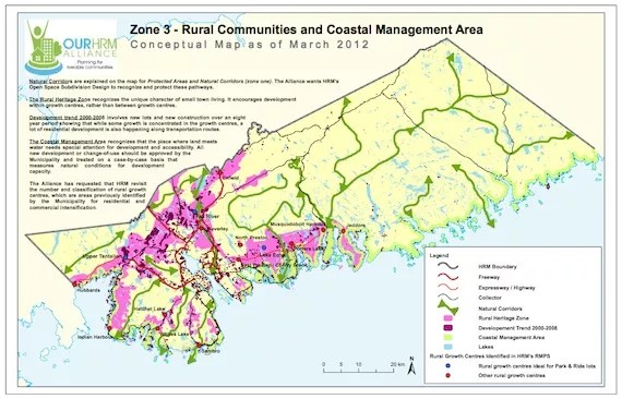
The land designated in this map makes up about 25 percent of HRM, and the future of that land is somewhat nebulous. The Alliance wants communities in the area to decide for themselves what future development patterns in their areas will look like, but while already-approved subdivisions will be allowed to go forward, the EAC’s Jen Powley says the plan calls for an immediate 20-year freeze on all other subdivisions. This will absolutely be the most contentious part of the entire plan, as developers who bought land on speculation, waiting for suburban sprawl to catch up with their far-flung holdings, will be hit directly in the pocketbook. We can expect big political fireworks over this as the regional plan review proceeds.
The fourth map, labelled “Regional Centre and Suburban Growth Centres,” is below (see a full-sized version of it here).
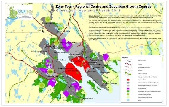
This map mostly reflects urban and suburban areas already mapped out in the first iteration of the regional plan, but the Alliance hopes to slow down suburban growth and increase growth in the “capital district” of the Halifax peninsula and in Dartmouth inside the Circumferential Highway.
To see how you can get involved in the regional plan review, click here.
This article appears in Mar 15-21, 2012.

Kind of hard to slow down urban sprawl when the heritage trust weenies stand in the way of almost all development in Halifax.
Kind of hard to increase growth in the “capital district” when Tim Bousquet is leading the charge to keep every building under seven stories
That is also a very balanced plan the “HRM Allianace” has come out with, five growth centres, all on the same fucking side of the city. The Halifax side. Brilliant!
One thing would go a long way to shape development, in a free market kind of way, and that would be widespread use of road tolls. You don’t need toll booths like at the bridges with MacPass; you can use open road tolling.
As it stands right now fuel taxes don’t adequately correspond to road usage. Thus, people who live in far-flung subdivisions are subsidized by people who live closer to where they shop and work. The fair approach for roads is “user pay”. We’ve got that for some forms of transportation but not for passenger vehicles.
Rather than impose artificial laws and regulations, simply get people to pay more of their fair share for what they use. New highway because of new subdivisions? The folks that live there should be paying for almost all of it. New schools because of those new subdivisions? Let’s hope that the people who live there pay for those schools. And so forth.
Protect wildlife and natural land as much as possible. There are far too many people on this earth and we have already destroyed most of the planet.
Yes, let’s not build anything more than 4 floors high on the peninsula, and let’s designate most of the developable land adjacent to the peninsula as a greenbelt, because HRM doesn’t have enough scrub trees already. Anything the EAC wants is usually wrong. Let’s all move to Truro!
A greenbelt is an excellent idea, I was just re-reading an older National Geographic (from 1990) that was extolling the virtues of greenbelts (though it was slanted more towards urban trails/rails-trails programs) so it’s great to see HRM get out of the 80’s.
Honestly, from an HRM gov’t point of view they don’t really have to do a thing. The Herring Cove Backlands, Long Lake Provincial Park, Western Commons, and Blue Mountain are already established (it’s kinda like dexter trying to take credit for the ships contract) so all they have to do is say ‘here it is’.
It’d be nice to see HRM kick in for some trails through or to those places though.