
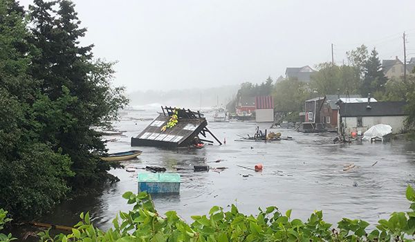
As the eye of Hurricane Dorian spun around Halifax Harbour like a cocoon, it could have been any other grey day in Nova Scotia—were it not for the building floating in the water in Herring Cove. The large boathouse was home to Thomas Reyno's three boats, two tubes and 45 years worth of memories. Now it more closely resembled an apple bobbing in the water.
"Never seen anything like this, just floatin' around," says Glenn Falcony in a video of the spectacle at Herring Cove, taken from behind a pair of windshield wipers in early September.
However, for Jamie Rouse, the owner of Boondocks Restaurant out in Fisherman's Cove, after his own close encounter with the water, the power of the sea no longer surprises him.
During a comparatively mild storm in January of 2018, Rouse and his son-in-law were standing on the boardwalk near Boondocks when the wooden slats beneath their feet started to move. "We got off of that pretty quickly," Rouse says, and "just basically came inside and watched it rip apart. It wasn't until the morning that we saw the extent of the damage."
What was left of Fisherman's Cove's boardwalk near the mouth of Halifax Harbour was a splintered mess. One half was embedded beneath the deck, and the other ripped up and shoved into the parking lot recall Rouse and Earl Gosse, a board member of the area's development association.
"It got shoved all the way over almost to the road, and that was lifting up concrete," says Gosse, "big concrete blocks, you know, a base—and they were down in the ground so it pulled them up."
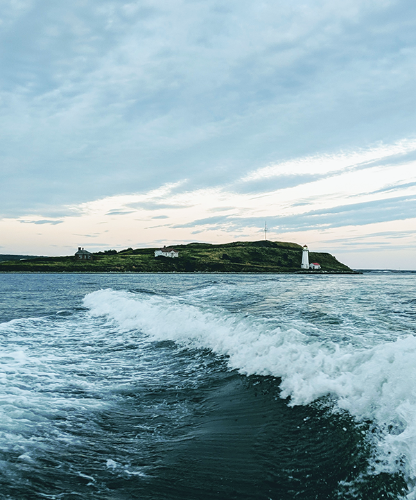
The Canadian Hurricane Centre reported wind speeds during Dorian of up to 130 km/h, while those recorded on the night of January 4, 2018 were a comparative whisper at barely over 50 km/h. For Fisherman's Cove, however, the devil was in the timing. Dorian arrived around low tide, when there was much less water for the wind to push around. While the January storm coincided with a spring tide, a higher-than-normal high tide that had swelled the harbour's surface to a nearly two-metre high water mark.
Imagine if the tide timing was different during Dorian. With water levels in the year 2100 expected to rise by 1.5 metres, or more, on a good day Fisherman's Cove would be completely underwater. (See interactive Fisherman's Cove comparison of 2002 and 2100 below, or get larger version here.)
However, despite Halifax Regional Municipality's proximity to the rising sea, its legislators are setting its future vulnerability in concrete. Millions of dollars continue to flow into raising the Halifax skyline, while policy makers are failing to seriously plan for these rising waters.
Rather than requiring all coastal buildings to be adaptive to higher waters, policy makers have preserved legislative loopholes that leave many buildings at risk. Without ambitious sea level rise legislation that protects all vulnerable coastal infrastructure, Haligonians in 2100 will be forced to pay the price in both livelihood and property, and many have started paying that price today.
Whether policy makers decide to act or not, HRM will one day have to reckon with its rising harbour, a rise that's been more than 100 years in the making.
Rising water
Reports of water level rise and rate vary. Some, like the International Panel on Climate Change predicitions, are more conservative than others. A 1998 map from National Resources Canada shows that more than two-thirds of Canada's coastline is actually at "low risk" from sea level rise due to our high, rocky shores. In some places, like Churchill, Manitoba, sea levels have even been rated as "rapidly falling."
Nova Scotia's eastern shore, however, is among the three percent of Canada's coastline that is rapidly receding. Blair Greenan, a sea level-rise scientist at the Bedford Institute of Oceanography, credits this phenomenon to the retreat of a massive ice sheet across Canada thousands of years ago.
"Think of the earth's crust sort of like a little rubber ball that the ice is squeezing," says Greenan as he curls his fingers around an imaginary stress ball. "Once you let the pressure off it sort of slowly rebounds back to its natural shape."
But the ice's frozen grasp didn't quite reach all the way over to Nova Scotia, he explains. This part of the land was like the uncovered part of the stress ball, which does "a bit of a bulge up." Once the ice began to retreat, instead of springing up into shape, Nova Scotia slowly started to sink back down into the ocean.
"When you compound that"—the sinking land—"with global sea level rise, we're seeing relative sea level rise here a little faster than the global average," says Greenan.
In fact, according to data collected since 1920 by the tide gauge beneath the A. Murray MacKay Bridge, the waters of Halifax Harbour have been rising at a rate of 3.3 millimetres a year. That's almost twice as fast as the global average, and it means the harbour is now about 30 centimetres higher than it was 100 years ago.
Because of this climatic double jeopardy, the 2019 Canada's Changing Climate report projects that, while global sea levels could rise by 1.3 metres by the year 2100, the surface of Halifax Harbour could rise by 1.5 metres, or more.
On top of that higher water comes the sort of wave action and storm surge that turned a minor storm into a destructive force in Fisherman's Cove last year. During an extreme storm, data analysis found that the harbour's waters could plausibly surge into parts of downtown Halifax's Hollis Street, up to 5.3 metres above the average sea level of today.
Hurricane Juan
While it may be 80 years before any sea water flows below the Old Triangle's stained glass windows, extreme water levels have already devastated the Halifax waterfront. Nearly two decades before restaurateur Rouse confronted his boardwalk, Halifax confronted Hurricane Juan.In the early hours of the morning on September 29, 2003, Hurricane Juan made landfall in Nova Scotia. As a category two hurricane with winds that reached maximum speeds of 185 km/h, the storm was of historic proportions.
"Hurricane Juan was truly a large-scale flooding event for Historic Properties," recalls Scott McCrea, CEO of the investment and construction firm Armour Group, which manages that boardwalk strip of historical waterfront buildings. While McCrea says extreme storm waters had repeatedly flowed past their granite and ironstone facades before, Juan unleashed waters that went all the way up to Water Street.
"For Historic Properties as well as much of the waterfront, it was just a shocking experience," says McCrea, "I think, in part, because no one truly expected that weather in force."
However, at a meeting in Dartmouth held shortly after the storm, emergency officials were already suggesting that a repeat of Juan was possible, if not likely.
"During the period we were working here, we were tracking another hurricane," said one attendee. "Only a fool would act on the supposition that it would not happen again."
Just over 12 years later, in the spring of 2016, McCrea was standing in front of the city's Design Review Committee, presenting Armour Group's waterfront plans for the stately Queen's Marque development. Envisioned in partnership with Develop Nova Scotia, the province's Crown corporation that manages its waterfront lands, the $200 million waterfront development was designed to pay homage to Nova Scotia's enduring nautical legacy, according to a May 2016 press release.
"It was a pleasure to look at the renderings," said one committee member, architect Anna Sampson. "The site is remarkable," remarked John Crace, another architect on the committee. Beyond a passing reference to the project's "proximity to the water," meeting minutes indicate that concern over its risk to sea level rise was not expressed.
By that December, Queen's Marque had edged even closer to the water, when the committee allowed Armour Group to scale back the minimum eight-metre setback from the high tide waterline to as little as three metres in some cases.
A little over one year later, in January 2018, while the boardwalk at Fisherman's Cove was being upended by that spring tide storm, across the harbour video journalist Steve Silva would wade through a torrent of flood waters flowing down the boardwalk along the Halifax waterfront. As he peered down into the construction site of the then-fledgling Queen's Marque, he would discover and record the sea water gushing into its foundation.The #QueensMarque construction site a few minutes ago. #NSStorm pic.twitter.com/GpnmXnNXR9
— Steve Silva (@SteveCSilva) January 5, 2018
"It's almost like the desire to be on the waterfront still outweighs the potential risks in the decision-making process," says Alexandra Baird Allen, of real estate consulting firm Turner Drake & Partners. "Those properties are more at risk, and that probably will continue for the foreseeable future."

Costs of sea level rise
In an email, Nancy Annigson of the Ecology Action Centre says documentation like Silva's recording is impactful for the public, because it visually identifies just what we are talking about along Halifax's waterfront."Coastal climate change can be frightening and overwhelming, information needs to be relatable," she says. "Seventy percent of Nova Scotia's population lives in coastal communities, people need to know and understand what is happening."
At the beginning of this month, the Insurance Bureau of Canada reported Hurricane Dorian cost Atlantic Canadians $105 million in insured damages. In Nova Scotia alone, personal, commercial and auto claims exceeded $64 million, the most out of the five provinces IBC reported on. Even Halifax Regional Municipality paid $450,000 for emergency tree removal.
According to Vanessa Barrasa, head of the bureau's Atlantic division, flooding in the region alone cost more than $10 million, a tenfold increase from the year before. Based on numbers reported in a 2018 media release from her organization, flooding from the month of January, the same month Fisherman's Cove's boardwalk went flying, made up the lion's share of the year's insured damages from flooding.
Down at the mouth of the Halifax Harbour, Fisherman's Cove board meeting minutes from January 10 and May 9 2018 reveal to repair the boardwalk would have cost nearly $10,000. "In the end we didn't have the money," recalls Gosse. "So we got a bunch of volunteers and a couple of forklifts, and we shoved it back in place and rebuilt it for free."
Even so, by February Fisherman's Cove's books were already more than $6,000 in deficit due to "significant maintenance costs" after the storm. Flood damage along Eastern Passage is nothing new, as a 2012 vulnerability map of the area produced by the city shows.
According to the map, many of Eastern Passage's coastal roadways have been "washed away or damaged by erosion and storm surge." At least three residential side streets have been "closed due to flooding," and 16 buildings were identified as having previously flooded.
Our data analysis suggests flooding like this may only be the beginning. By 2100, more than 400 buildings along the shore of Eastern Passage lie in an area that could potentially be inundated during an extreme storm. While these extreme waters could threaten more than $76 million in today's tax-assessed property values in the area, across the harbour along the Halifax waterfront, more than $939 million in today's tax assessed property values could be at risk.
When the entire harbourfront is considered, nearly $1.94 billion worth of today's coastal real estate could lie in the path of extreme water levels by 2100.
And as high as that dollar figure is for Nova Scotia—where this year's provincial budget is around $11 billion—it is almost certainly a conservative one. It only considers the value of each building according to its tax assessment. "It's really a best-case scenario," explains realty expert Baird Allen over the phone. "It doesn't cover the value of the contents, and it doesn't cover the value of the business interests, so those are going to be costs over and above any damage to the construction of the building."
According to a 2015 HRM case study from the Insurance Bureau of Canada, the impacts from sea level rise over the next 20 years alone could increase the costs to repair damaged infrastructure by as much as 85 percent. However, the "direct and secondary" impacts on the province's GDP from that infrastructure's lack of productivity would be much higher.
By as early as 2040, annual losses from coastal flooding could be increased "by a factor of seven," from $400,000 to $3.1 million a year, says the study. If another Hurricane Juan were to happen on waters just 20 centimetres higher than today's, it could scrape out up to $29 million more from HRM's GDP than it would if the historic storm were to happen today.
Adapting
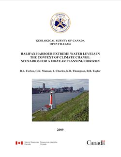
Less than a year after the destruction of Hurricane Juan, HRM's policy makers began to take action. By the summer of 2004, they started to make note of the emerging concern of climate change and rising sea levels, and requested a modelling study to predict its impacts by 2100 on the shoreline of Halifax Harbour."We cannot afford a wait and see approach when it comes to climate change," said Roger Wells, then-supervisor of the city's Planning Department shortly after the modelling study was finally completed in 2009. "That's why we're planning now for the next 100 years."
Back in 2006, while policymakers were still waiting for the modelling study's results, HRM adopted a new land-use bylaw that required any development along the coast to build residential space at least 2.5 metres above the normal high tide level. However, when the study's results finally came out three years later, the city decided to leave the minimum elevation where it was, instead opting to convert it in 2014 to a roughly equal but fixed elevation of 3.8 metres above the 1928 sea level for a more modern and consistent standard of measurement.
"Council chose 2.5 metres above the ordinary high water mark in order to be really conservative and account for a pretty extreme scenario," says the city's Energy & Environment Program manager, Shannon Miedema.
"That is where you can't build residential floors of new developments: below that line, for the entire coastal area."
We cannot afford a wait and see approach when it comes to climate change. That's why we're planning now for the next 100 years.
tweet this
While HRM's bylaw does attempt to ensure no new homes will lie too close to the surface of the sea, the elevation of other spaces in the buildings—think the non-residential parts of an apartment tower, like the parking garage or street-level retail spaces—are largely left up to the discretion of individual developers. A few have taken it upon themselves to exceed the city's minimum standards, opting to raise more than just their buildings' residential floors.
In 2008, Francis Fares would be one of the first developers to go above (literally) and beyond the regulations, deciding to focus on the "elevation on the whole development" for his Dartmouth waterfront buildings at King's Wharf.
"It's only a matter of time before the sea rises so we said, 'let's go a little higher,' it's that simple," he says.
Not stopping at 2.5 metres above high tide, Fares says he raised King's Wharf's residential levels a further six metres above his lowest floors; a total height of almost eight metres above high tide. His lowest level, P2 for parking, is 1.8 metres above high tide, according to a risk assessment he submitted to the city in 2017.
"You don't want your buildings stuck up in the air so they don't interact with the water, but then again...you don't want to have your buildings submerged in water," says Fares. "You have to do a happy medium, and that's what we decided to go with."
Across the harbour on the Halifax side, McCrea was wrapping his own head around sea level rise when, in early 2016, Armour Group and Develop Nova Scotia began to draw up the waterfront plans for Queen's Marque.
"Because we've been making a massive—and it is a massive—investment on the water with Queen's Marque," says McCrea, "it would be foolish for us not to anticipate some level of sea rise over the next 100 years. We've done that in terms of the elevation of the project and in terms of the water proofing."
Queen's Marque's residential units begin at roughly six metres above today's high tide level, and its commercial ground floor is elevated roughly 1.6 metres above high tide according to the site plans Armour Group submitted to the city.
However, with seawater already pouring into its construction site as early as last January's storm, the question remains of whether even the building's elevation is really high enough.
Policy versus science
"You [can't] have something stuck way the hell out of the ground," says Peter Bigelow, director of planning and development for Develop Nova Scotia. "It's not as simple as building something on stilts, 'cause then it doesn't work with the rest of the city."For one thing, HRM's Citadel View Planes legislation requires all new buildings be built low enough to protect the harbour views from the top of Citadel Hill. While the legislation is significant from a historical and cultural perspective, it's been a nightmare for most downtown developers to contend with.
"I know that for a couple of developments that I'm aware of, you raise [the building] for sea level and then you're squished in over the top with view plane legislation from the Citadel," explains Bigelow. "Suddenly you lose a whole floor because of just a matter of six inches." Overhauling designs and business plans would ensue.
Without similar height restrictions on the Dartmouth side of the harbour, Develop Nova Scotia was able to ambitiously elevate its Center for Ocean Ventures and Entrepreneurship, or COVE, which was completed last summer. Part of the infilled site for the collaborative facility for ocean research is raised 3.1 meters above today's high tide level.
According to COVE's 2013 guiding plan, its elevation is informed by Scenario 3C from HRM's sea level rise modelling study; a projection that more closely matches the one used our data analysis. It says unlike Scenario 2C, which informs the minimum elevation in the city's bylaw, "Scenario 3C represents a more recent update of sea level rise projections and considers the partial melting of the polar ice caps, which Scenario 2C did not include."
While Miedema says the modelling work validated the bylaw's 2.5 metre elevation, the study actually warned planners Scenario 2C's underlying IPCC projections are known to be "overly conservative." That's why it also included Scenario 3C in its analysis: In order to allow the city to err on the side of caution.
All of this matters because if the city's elevation legislation falls short, the wetter and more expensive it's going to get.
After the Insurance Bureau examined HRM's current land-use policies in a 2015 case study, it found if business carries on as usual, buildings planned between now and as early as 2040 will account for almost two-thirds of all flood-related damages.
Data analysis found that over the last 10 years at least 95 new buildings have already received permits for new construction along the harbour. These permits are for buildings below an elevation that could potentially be at risk to extreme coastal flooding.
Even below the city's minimum elevation for residential floors, about 2.5 metres above the high water mark, at least 72 brand new developments have already been approved for construction since the bylaw was first adopted back in 2006. (See interactive map of approvals—click a dot for the value of that property—below, or get larger version here.)
As long as the bylaw's minimum elevation narrowly applies to residential floors only, entire buildings will remain legislatively defenseless to the rising waters.
Planning for the future
Miedema says the elevation of the bylaw was only ever meant to protect residential spaces, but "with new information in the lead up to and since [the IPCC's latest projections], we see an opportunity to enhance the bylaw, and consider extending it to commercial properties as well."
Before any new commercial buildings can be raised an inch, however, Miedema says HRM will have to wait for an upgrade to its 2007 LiDAR, or Light Detection and Ranging data, which is necessary to topographically map Nova Scotia's coasts and study their rising waters. As helicopters fly across the province's 2,400 km of coastline, bouncing down lasers and scanning the contours of the earth below, policy outcomes in key pieces of sea level rise legislation remain pending.
Package A of the Centre Plan says it is committed to "raising the elevation of developments in response to sea level rise."
However, despite being approved by Regional Council just last month, an earlier version of the plan says any sea level-rise-related policy change would have to wait until the release of Package B and the "upgraded LiDAR survey data."
The same is true for the pending regulations of the Coastal Protection Act, passed in the provincial legislature this past April. While its regulations will eventually roll out minimum elevations above the coast for all new developments across the province, the city's principal planner, Ben Sivak, says they will also have to wait for the results from the new LiDAR dataset.
Even so, the province's Coastal Protection Act is "a terrific piece of legislation," says Anningson from the Ecology Action Centre, which has been rallying for provincial coastal protection legislation for more than a decade. The act considers "coastal climate change realities and the need to...restrict coastal development in inappropriate places, [finally making] things more consistent and effective," she says.
"Although there are still baffling things that happen such as waterfront developments that are too close to the coast, [the act represents] a big change over the past year."
"Halifax Regional Municipality has done a lot of work…but there is still a lot of work to be done." —Nancy Anningson, EAC coastal adaptation coordinator
tweet this
Once the new regulations are in place, the coastal protections embedded in the act will be a big step for most Nova Scotian municipalities, many of which still don't have any building setback requirements at all. But they may do little more than play catch-up with the policies already in place in HRM, "a leader in the province when it comes to coastal climate change adaptation," says Anningson.
Even once sea level rise legislation like Package B of the Centre Plan is ready to go, Sivak says it shouldn't be taken for granted that the bylaw will actually be expanded beyond new residential levels. "I don't think anything's off the table," he says, but "a big part of Atlantic planning is balancing multiple different interests."
Balancing act
One interest is waterfront proximity, which is essential in enriching the province's tourism industry."Nova Scotia's accessible coast offers many diverse opportunities for tourism operators and visitors to engage with Nova Scotia's natural beauty," wrote Tourism Nova Scotia spokesperson Zandra Alexander in an email. "We know that many people come to explore the sea coast, beaches and ocean, and experience the world's highest tides."
Over the next three years, Tourism Nova Scotia's Tourism Revitalization of Icons Program will invest $6 million to enhance five coastal destinations across the province: Peggys Cove, the Cabot Trail, the Bay of Fundy, the Lunenburg waterfront and the Halifax waterfront. If history is any guide, the $1.5 million allocation to the latter destination is an investment that will likely pay for itself.
According to Develop Nova Scotia's 2018 annual report, over the last seven years an estimated 4.6 million non-residents have spent $1.6 billion in Halifax waterfront-attributable spending. In 2017, a record 2.9 million pairs of resident and visitor feet alike have stomped along its boardwalk's wooden planks to play by the Halifax seashore.
"The coast is where people want to be, there's lots of businesses that rely on being close to the water," says Sivak. "It's an effort to try and balance those interests of waterfront developments and so-on, with our responsibility to take into account public health and safety."
In order to reconcile this tension, Sivak says he relies on a "common distinction between someone's place of living and someone's place of business."
If "people can't get into their home that's a problem, that's a big challenge," he says. "If someone's business gets damaged from storm waters, yes that's a hardship, but at least they have a place to go home to.
"Whether or not this is the best balance going forward is an ongoing conversation in Halifax and across the world, for that matter, and it's something that I expect we will be revisiting again and again in the coming years."
Business as usual
In the meantime, another multi-million dollar publicly funded building situated right at the harbourfront's edge has been approved. Just a few days after the Coastal Protection Act was signed into law, the province announced the relocation of the Art Gallery of Nova Scotia from its downtown location on Hollis Street to a $130 million modern, new gallery at the very bottom of Salter Street. (See interactive AGNS site comparison of 2003 and 2100 above, or get larger version here.)"I can't think of a better place than finding a location on our waterfront," said Nova Scotia premier Stephen McNeil to the Globe and Mail earlier this year about the AGNS's new home. He was unavailable to provide a direct comment for the Coast.
"The scientific evidence that those properties are more at risk...is there, but the desire to be on the waterfront still exists," says realty expert Baird Allen. "That mindset hasn't changed yet and it's debatable when and whether it really will at some point change. There is a lot of attraction to building on the waterfront, people still want to be close to the water."
As Develop Nova Scotia's Bigelow sees it, he doubts that will ever change.
"I don't see as a society for us totally abandoning the coastline," he says. "They offer us a richness, a fantastic place to live."
For his partner on Queen's Marque, Armour Group's McCrea, even the suggestion to question waterfront development is where the sea level rise discussion "becomes almost absurd."
"Yes, it's a concern, but past a certain point you would start to question any development on the peninsula, or any coastal development in Canada or the US," he says. "One would have to come up with very catastrophic predictions to believe that downtown development can't and shouldn't happen."
"If it gets to a certain level over the next 100 years, the problem becomes so big that it's something we're all going to face."
Nicoletta Dini is a proud east coaster, a concerned environmentalist and a single mother of Luca and Leonardo. She is currently working towards a Bachelor degree in science at Dalhousie University and recently completed a Master of Journalism degree at the University of King's College. This story is based on Dini's professional project for that program.